Contents
What is public transport density?
We’ve created a way to identify how public transport friendly a country is. The purple highlights all the areas of a country that can reach some sort of public transport service.
What can it be used for?
- Public transport network planning and development
- Travel plans - how easily can tourists explore the country using public transport
- Predicting commuting/travel habits in a local area
- Identifying the cause of road network congestion
How we built the map
We started by plotting every single public transport stop in Germany. Then we drew a 15 minute walking catchment area around each stop to capture anyone in the local area that needs to walk to a local train, bus or tram station.
How to read the map
The more purple the area is, the greater the public transport density of an area. The white areas show where public transport is not reachable.
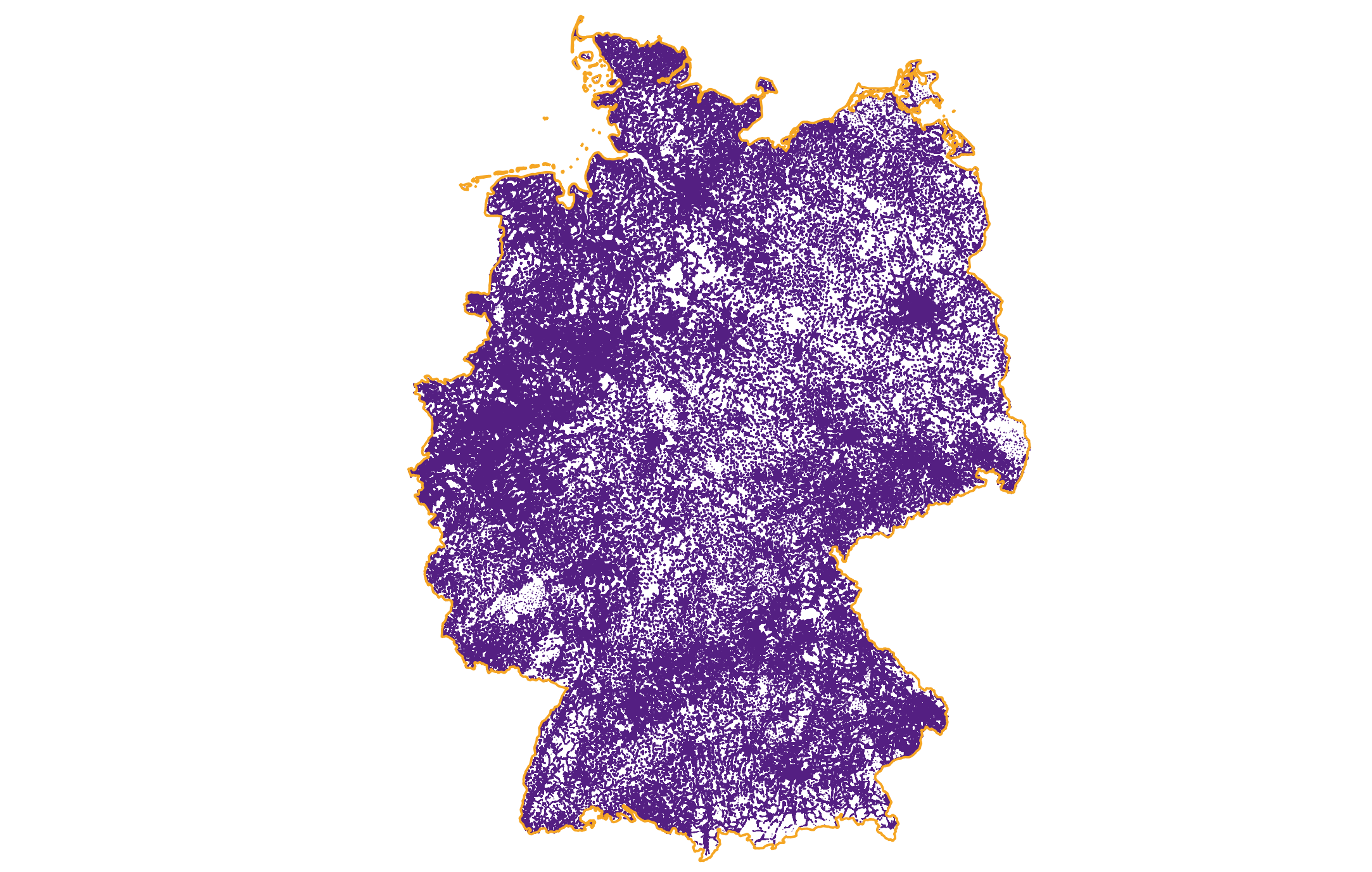
What it shows us about Germany
- Germany has great public transport coverage
- The white areas in Germany are usually due to:
- Low population density - not enough local demand for public transport services
- Land usage - areas that are primary used for agriculture
- Geography - rivers, lakes and mountains
Combining public transport data layers with land usage and population levels helps us identify areas ripe for development.
Public transport density map limitations
Transport timetables - it can appear that an area is not in need of transport development if it’s purple. However if the highlighted route only runs once a day, it’s not giving local residents a lot of transport connectivity.
The makeup of Germany’s transport system
Germany has a very advanced and varied public transport system (bus, tram, underground, light rail, regional train), with plans to expand the local public transport network even more, and make as much of it as possible electric. The city of Wuppertal has a unique mode of public transport - a suspended monorail that's about 120 years old (began operation in 1901).
Our favourite Germany transport route
Bus 100 in Berlin. It has the best route for sightseeing. It takes you from Alexanderplatz to Zoologischer Garten, passing the TV Tower, Berliner Dom, Museum Island, Brandenburg Gate, Reichstag, Bellvue Palace, Victory Column, Tiergarten, and Kaiser Wilhelm Memorial Church along the way.
Our favourite stop & why
Marienplatz underground station in Munich. It is located at the very heart of Munich old town, in the Marienplatz square, right next to the Town Hall and other famous central sites - Isartor gate, Odeonsplatz square, Sendlinger Tor gate and others.
Next Steps
We have created one of Germany's largest public transport databases - and do the same for 100+ countries around the world. Explore our data further:
- Create your own travel time catchment area: see where's reachable within a travel time limit
- Try our API Playground: are you a developer? Explore the code behind our API
- Explore our products: see what's possible with TravelTime